New Navigation Techniques for Arctic Exploration
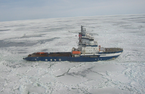
Icebreaker Fennica was holed off the
coast of Alaska
In today’s world of instant communications, constant connectivity, and virtual reality, it is easy to forget that there are still vast expanses of our world that are undiscovered and unknown. Polar regions make up much of that vast unknown. Yet in the past few years, the number of vessel excursions into these areas is increasing steeply. Shipping, tourism, oil exploration, science, and EEZ expansion are all driving this surge. With this surge comes increased risk of navigational hazards as many of the “classic” navigation tools (recent surveys, stable buoys and channel markers, and good gps coverage) are not available or practical in these areas.

Portion of NOAA Chart 16530 (Captains Bay, Unalaska Island) showing water sufficient for navigation where an uncharted shoal exists and holing occurred (soundings in fathoms).
Nautical charts are intended to provide baseline navigation information for vessel operators. As every captain knows, charts only tell you what was there the last time a survey was made, and the results were included in the chart. The usefulness of a chart in a given area is a function of:
Depth measurement method (including area of coverage, spacing of measurements within that area and accuracy of the measurement),
Location accuracy (how well was the location of the original measurement known as well as how well does the vessel know where it is currently located),
Dynamic changes to chart area (such as seasonal changes to sandbars, movement of boulders and other hazards due to storms, natural disasters, ice flows, etc., the addition of new hazards due to war, new shipwrecks, etc.), and
Presence of transient obstacles (such as whales and lost shipping containers).
![By U.S. Coast Guard photo [Public domain], via Wikimedia Commons](https://images.squarespace-cdn.com/content/v1/60cce3169290423b889a1b09/87298373-1671-4866-9c46-6cd9c48268e1/Shipping_container_floating_off_Port-au-Prince_2010-01-13.png)
Shipping container floating off Port-au-Prince
Though a consideration in all waters, the above concerns are amplified in the polar regions. In many of these areas, little or no chart data is available, and standard GPS accuracy can be more than 10 meters. Even worse, in some areas, sparse chart data can affect vessel safety more than zero chart data. Due to sparse chart coverage, the vessel operator may think they are operating in well surveyed areas, and that all fixed hazards are documented. This may have been the case in the holing of MSV Fennica while operating off the coast of Alaska. This is proof that even ice breakers run into trouble in polar regions.
Future navigation in the Northwest Passage may see a blockage of routes by the southern shift in pack ice and an increase in drifting Old Ice creating choke points in narrow channels and navigation hazards
The Canadian Ice Service warns that “predictions of an ice-free Arctic may lead many into a false sense of optimism regarding the ease of future shipping. Sea ice is highly variable and there will still be summers of occasional heavy ice conditions. Future navigation in the Northwest Passage may see a blockage of routes by the southern shift in pack ice and an increase in drifting Old Ice creating choke points in narrow channels and navigation hazards”
Today, FarSounder’s current navigation sonar products are suitable for exploration vessels and are already helping mariners mitigate the limitations of classic navigation tools in polar regions. FarSounder’s intuitive user interface displays include a 3D sonar display as well as chart overlay. Forward looking sonar data from FarSounder sonars can even be integrated into select 3rd party ECDIS systems.
In the future, FarSounder envisions further advances in data visualization options. For example, data from 3D Forward Looking Sonar could be fused with historical databases to dynamically update electronically displayed charts. Another method could be to dynamically generate Virtual Aids to Navigation (AtoN) which could be displayed on an ECDIS chart in areas of austere bathymetric coverage. One could further envision that such generated aids could be stored for future transits and/or shared with other vessels. In all cases, safety zones as detected by a real-time 3D navigation sonar would be demarcated on the chart using existing virtual AtoN symbology.
Though initial trials have shown that FarSounder sonars could be used in a Forward Looking Multi-Beam method, one should not infer that 3D forward looking sonar negates the need for charts and surveys. The two serve different purposes. However, the viability of using FarSounder’s FLS data for the generation of Virtual Aids to Navigation is analyzed in Vector Data Extraction from Forward-Looking Sonar Imagery for Hydrographic Survey and Hazard to Navigation Detection, a paper recently co-authored by R. Glenn Wright of the World Maritime University and GMATEK Inc. and FarSounder’s CEO, Cheryl Zimmerman.
When navigating in locations where chart is incomplete it is quite reasonable to ask how well would 3D forward looking sonar work to assist in navigating safely. Contact us to learn more about fitting your vessel with one of our navigation sonars.