FarSounder’s Sharing Across the Fleet Program
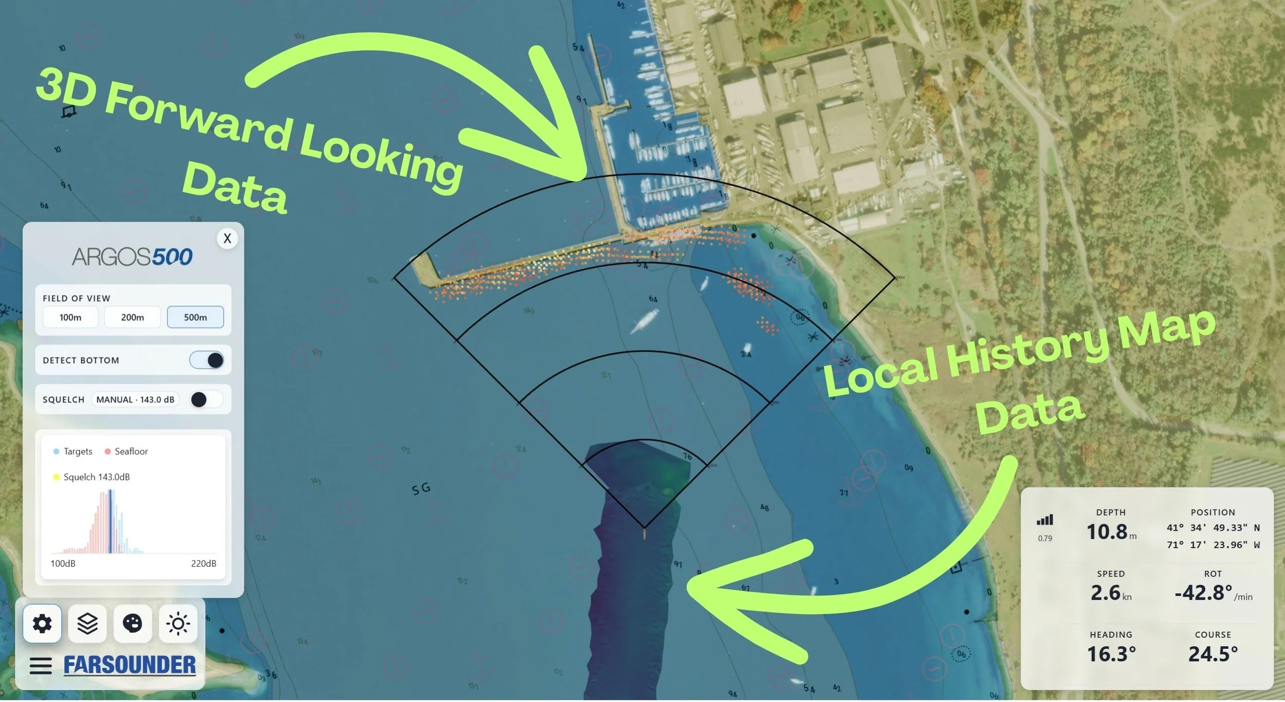
Our Argos sonars produce two types of data: 3D Forward Looking Sonar data (that’s the realtime image ahead of the vessel, inside the sonar’s field-of-view) and Local History Map™ data (the depth map of everywhere the vessel goes).
By default, all data lives aboard the vessel on the FarSounder bridge computer. However, users can opt-in to anonymously share their Local History Map data across the FarSounder fleet. In exchange, they receive the aggregate map built from everyone’s contributions. Plus, we contribute depth measurements anonymously on their behalf to Seabed 2030, a global effort to help map the world’s oceans.
Additionally, your own Local History Map data is backed up to our cloud service when shared, making it easy to transfer the data to a new computer or recover from a computer fault.
How to Participate
Participating in FarSounder’s data sharing program is easy! Because of FarSounder’s privacy first policy, this functionality is disabled by default. Simply enable the functionality in SonaSoft’s settings:
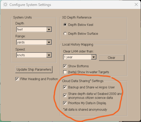
Once enabled, SonaSoft will automatically synchronize data whenever an internet connection is detected by the software. All data is cached locally. Therefore, continual internet access is not needed. Internet access is only needed when synchronizing.
Internet Access Requirements
Though internet access onboard vessels is becoming standard, ensuring adequate bandwidth for all operational and entertainment purposes in all geographic locations is not yet ubiquitous. Therefore, we’ve designed our data sharing functionality to operate in a hybrid on-line/off-line environment. Internet access is only required when you wish to synchronize data (i.e. upload your depth map to our cloud service and pull down the latest updates to the aggregate map.)
Some customers always leave the FarSounder bridge computer connected to the internet. Others keep the computer offline and physically disconnected by default, then use a USB-wifi dongle to manually connect it to the ship’s wifi when they want to go online. Still others do something in between where they use router settings to only allow internet access at specific times or at specific throughputs.
FarSounder’s software automatically checks for internet access and initiates synchronization whenever access is detected. The initial download of the complete aggregate map will require a few 10’s of gigabytes. After that, you should expect 10’s to 100’s of megabytes per day when cruising in coastal areas. The actual data requirements depend upon how much data you’ve collected and how much of the aggregate map has been updated in a given timeframe.
Privacy Concerns: What Exactly Gets Shared
When participation in the data sharing program is enabled, there are two primary data streams that are shared with FarSounder’s cloud service: NMEA data input to the FarSounder software and gridded depth data used in the system's Local History Map. These data streams include time and location data but do not include vessel name, vessel contact information, crew information, IMO number, MMSI number, or any other vessel registration information. They do include a FarSounder generated unique ID that is used to associate all contributions to a single vessel platform, the serial numbers of the FarSounder hardware, and vessel’s sensor layout information (sensor offsets, draft, vessel length, etc.) configured in the software.
Contributions to Seabed 2030 on behalf of FarSounder’s customers are made via the International Hydrographic Organization (IHO)’s crowdsourced bathymetry databases which are operated and maintained by the US National Oceanographic and Atmospheric Administration (NOAA). These contributions include the FarSounder generated vessel unique ID, date/time, location, and depth information, as well as information derived from the vessel’s sensor layout. These contributions do not include vessel name, vessel contact information, crew information, IMO number, MMSI number, or any other vessel registration information.
The cloud servers used by FarSounder for our data sharing services do not connect to, and are not interfaced with, the systems FarSounder uses to store customer records. Therefore, confidential customer information cannot be accidentally sent to the NOAA databases. NOAA’s databases do allow for optionally including vessel name and other vessel identifying information, and some FarSounder customers do wish to have their contributions to Seabed 2030 via NOAA’s databases attributed to them. In these cases, FarSounder engineers must look up the vessel identifying information from their customer records and manually enter it into FarSounder’s data sharing servers. There is no automatic connection that can be accidentally or intentionally compromised.
Are the Contributions to Seabed 2030 Available to the Public?

Individual contributions to Seabed 2030 are made available to the public via the databases operated by NOAA. Though NOAA collects contributions from any location, only contributions located in international waters, or territorial waters of countries who have explicitly allowed the IHO’s crowdsourced bathymetry activities are made available through their public facing interfaces.
Additionally, the aggregate map collected under the Seabed 2030 initiative is available from GEBCO and is known as the General Bathymetric Chart of the Oceans. (Fun fact: when you look at Google Earth, the bathymetry they show is GEBCO data!)
How to See What’s Been Contributed
We’ve made it easy for anyone to explore any of the crowdsourced bathymetry contributions (not just FarSounder customer contributions) that are publicly available via NOAA’s Data Center for Digital Bathymetry (DCDB) with our CSB Data Explorer tool. This tool lets you explore the data collected by a single “Trusted Node” (i.e. a facilitating organization such as FarSounder, the International SeaKeepers Society, etc.) or by a specific “Platform” (i.e. ship or boat). In the case of FarSounder customer contributions, the Platform ID is the FarSounder-generated vessel unique ID.

Our CSB Data Explorer makes it easy for you to see what you’ve directly contributed (assuming you know your FarSounder-generated vessel unique ID) and to share it with friends and colleagues. The site has been optimized to share your contribution stats nicely on social media. We hope that by sharing this message, other vessels will join the Seabed 2030 cause.
Individual data sets can be downloaded from NOAA’s Data Center for Digital Bathymetry directly.
Additional FAQs
Is there a cost to participate?
No. This service is provided at no cost to Argos Sonar customers who share their Local History Map data anonymously.
I’d like to show off and have my vessel’s name included in the contributions to Seabed 2030. Can this be done?
Because of FarSounder’s “privacy first” policies, adding your vessel name to the contributions cannot be enabled by our customers and cannot be done automatically. FarSounder’s engineering team can manually add this information to the contributions. Please contact FarSounder directly for assistance.
Can I backup my own Local History Map data to FarSounder’s cloud service?
Yes! This is done automatically once your data is synchronized. Should you need to replace your computer, the software will be able to redownload your own Local History Map data.
What jurisdictions are included in this program?
Your vessel’s own Local History Map data is available worldwide. However, the map generated from aggregated contributions is only available in international waters and the territorial waters of countries that have explicitly allowed IHO crowdsource bathymetry activities.
Why participate?
Participation in the project will give you
The ability to back up the data you collect with your Argos Sonar to the cloud
Access to bathymetric data from other customers in the pilot program
Your participation will also benefit the global community via anonymized data contributions to the IHO’s crowdsourced bathymetry efforts and Seabed 2030. For example, FarSounder customer in the Canadian Arctic recently collected and submitted data to the IHO’s database that was then incorporated into the update of Chart 7053 by the Canadian Hydrographic Service!
What is my liability for the data I contribute?
None! All data contributions are made in a “good faith effort” and contributed “as is” without guarantee or warranted accuracy. This means that although these data are of high quality and useful for planning and modeling purposes, they are not official charts, and they are not held to official chart survey standards. Official charts should be obtained from the appropriate hydrographic office or their resellers.